 Statement of Work
Guzi-West Adds GIS Capabilities
Intro: Our newest team member, Seamus Begley, is a recent Humboldt State graduate who has formal training in Natural Resources and GIS. He brings a fresh perspective to Guzi-West’s growing location intelligence program which develops geospatial resources and helps the sharing of cartographic products (maps and similar information) to our clients to aid in their decision-making.
History: GIS or Geographic Information Systems are a framework for capturing and analyzing location data. Since the 1980s, GIS has been used heavily through varying sectors and organizations to solve complex problems. GIS is used in all levels of government to organize and store information that spans large areas. For example, layers depicting, utilities, roads, and zoning areas. While GIS normally has a very high entry cost – which bars smaller organizations from using its powerful functions – recent strides in open-source alternatives have made it less expensive. Guzi-West is proud to use QGIS and other flexible open-source packages to deliver solutions to our clients.
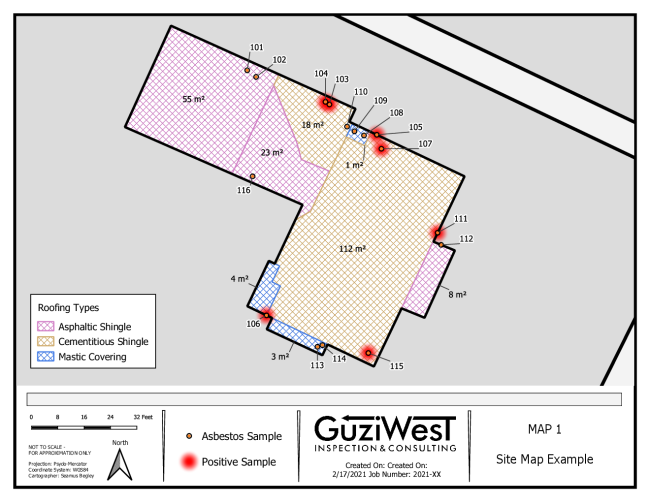
Methodology: Our maps help provide an idea of where samples were taken, and how large a project may be. The maps aren’t survey grade but can provide quite accurate measurements depending on the project specifications. ‘
Creation of a map starts when a field crew performs a survey and sketches a field map, including the points where samples were taken. GIS staff receive the maps as a scanned copy and georeferenced to the top of a building outline. The building outlines are generated through open-source project created by Microsoft and proven to be accurate. There may be some cases where aerial imagery or other means are also used to approximate the outline of a building. Finally, staff digitize the field map over the building outline to give an approximate layout of the project footprint and sample locations. One of the benefits to using GIS is creating and storing information as spatial data. It’s incredibly easy to make updates, render new maps for re-assessments, or get multiple views of the same structure.
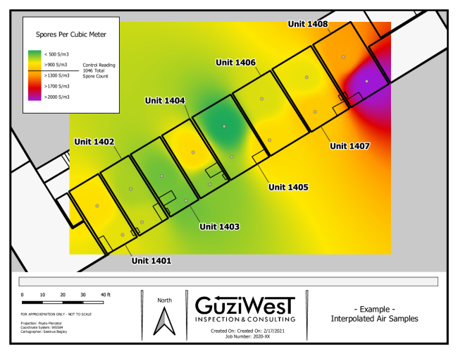
Conclusion: Our team has the capability to do more than just create simple maps. GIS is not widely used in the construction occupational health industry, which make it even more exciting for us to explore new applications and apply them to solving problems. Spatial data creation and management, interpolation / predictive modeling from existing points (Map 2) and other advanced analyses are all within our capabilities.
If you have a project in mind which you think could benefit from our GIS expertise, please reach out to the Guzi-West team to talk about the possibilities.